The L-KOPIA/LKO LD Clearance Laser System
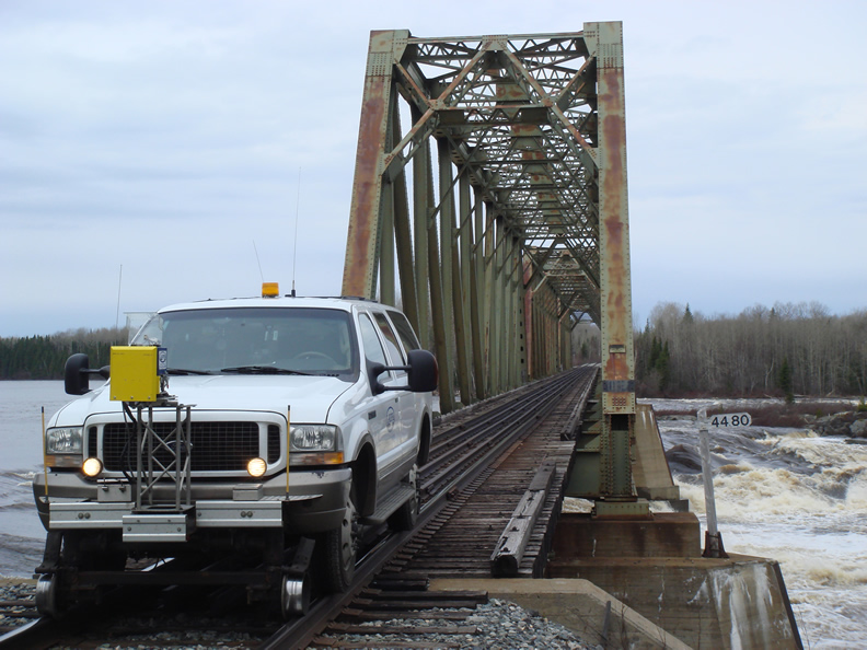
The L-KOPIA/LKO LD Clearance Laser System is fast (9,600 to 43,200 points/sec), accurate (down to +/- 4 mm or 1/8 inch), has high resolution (down to one point every 0.125 degrees), has a measuring range from 0 – 70 meter (0 – 230’) and scans 360 degrees. The system is still 100% eye safe (Laser Class 1) and operates under most environmental conditions (also in full daylight and total darkness). The LD laser is light weight and small in size.
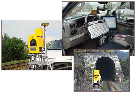
The LKO/L-KOPIA Clearance Laser System consists of the LD laser hardware from one of the largest laser manufacturer in the world. The LKO/L-KOPIA LD laser is specially calibrated to match our high end specifications.
The NEW LKO/L-KOPIA Laser System also includes an electronic odometer, an electronic pendulum for cross and longitudinal level, a CCD camera system with superimposed text (continues mile readings, track segments, track numbers, direction) from the XP-based LKO/L-KOPIA laser software. Optional is GPS data intergraded in any of our data formats.
The LKO/L-KOPIA Clearance Laser System has been used in North America, Europe, Far East and Australia since 1993. LKO/L-KOPIA has over 30 systems worldwide. Some systems are owned and operated by customers and some are operated by LKO/L-KOPIA for contracting services.
The LKO/L-KOPIA Clearance Laser System produces clearance & surveying data for several applications, such as Ballast Profile and Volume calculations, Clear Load Simulation, Clear Load Diagrams, Plots and Ballast Diagrams in different scales, AutoCAD conversion and Minimum Track Center Calculation. Data files from the LKO/L-KOPIA system are compact and can easily be e-mailed from field units to processing offices.
L-KOPIA/LKO also designs software for conversion of our standard data-format into our customers’ Mainframe Dimensional Load Programs. Furthermore, we offer our railroad customers tailored L-KOPIA/LKO ClearLoad software. Please contact us for customer references.
Applications for the LKO/L-KOPIA Clearance Laser System:
• Total Clearance Surveys (optional with DVD recording and GPS data collection)
• Total Ballast/Roadbed Surveys (including profile and volume calculations)
• Total Track Center Distance Surveys (including Roadbed Profiles)
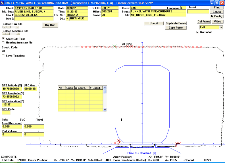
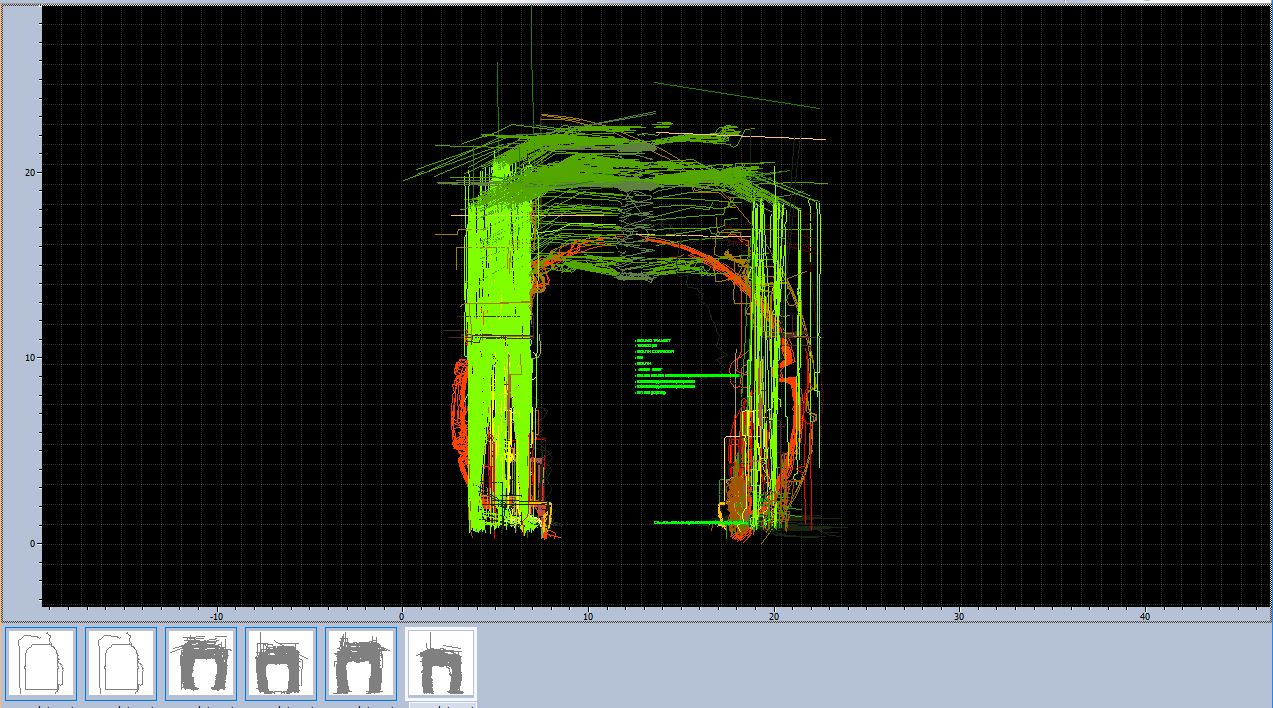
• Cross sectioning, area and volume calculations in tunnels
• CCD camera filming (separate or together with laser surveys, including superimposed mile/km readings, track segments, track numbers, GPS data, etc. )
• Load Surveys (checking clearances for oversized loads, real time on track, on road and on water)
• Express Roadbed and Track Center Surveys (including ballast volume calculation)
• Platform Maximum Gap Surveys (real time or in post processing)
The LKO/L-KOPIA laser software is built on 16 years of experience from earlier laser software versions. As before, we have several side programs to adapt the LKO/L-KOPIA output to other applications, such as ClearLoad, WideLoad, Ballast Diagrams, AutoCAD and GEO- 12.
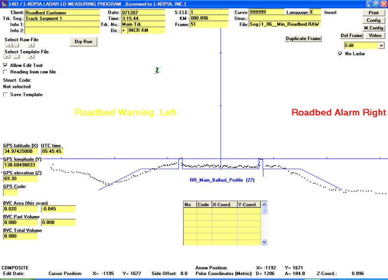
The Ballast Option includes calculations from given Roadbed (Ballast) Profiles.
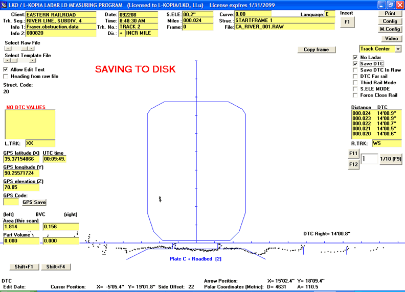
In Track Center Mode center line to center line distances are continues saved with mile/km information (see yellow window to the right in picture). We can measure two (2) adjacent track simultaneously. GPS and Ballast data can be included.
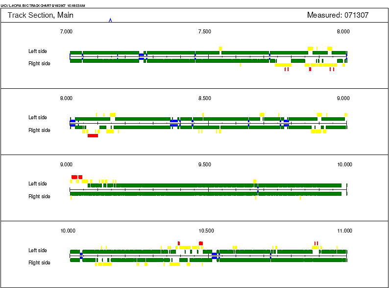
The LKO/L-KOPIA Ballast/Roadbed diagram shows were to add ballast (also side) and total condition (green, yellow or red).
Measured by L-KOPIA CLEARANCE LASER SYSTEM
(c) L-KOPIA
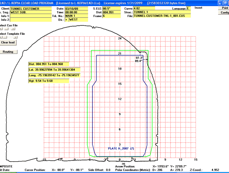
Client : TUNNEL CUSTOMER
Date measured : 03/10/09
Track segment : WEST SUB.
Track number : MAIN 1
Direction : WEST
Curve & S.ELE : 4.017 00.5″
Distance & Structure : 004.951 004.960 TUNNEL 1
GPS (Lat/Long/Hgt) From : 39.99627994,-75.19639142,9.54
GPS (Lat/Long/Hgt) To : 39.99641384,-75.19634577,9.68
File & frame No. (mode) : 001 06 (C)
The L-KOPIA/LKO ClearLoad Program © has several design options for the end result (scale and grids for Imperial & Metric, with or without clearance distances on plots, Safety Margins shown on Plots, etc.). The ClearLoad software also includes a “Routing Option”, with customized “System Maps”. Plots can be sent to printers, plotters and to PDF-printing.
LKO/L-KOPIA has a conversion program from our CUS file format to DXF for use in AutoCAD.
For further information, please contact us via e-mail, phone, fax or mail.